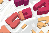
A simple guide for 3D visualisation of buildingsUsing the OS National Geographic Database’s new buildings data attributeOct 4, 2024Oct 4, 2024
Published inPython in Plain EnglishCreative CSS with Raster MapsOrdnance Survey’s iconic maps and authoritative data sets are available to download, including a sizeable suite of completely free…Oct 20, 2022Oct 20, 2022
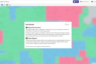
New web-based data currency toolCheck out a new currency viewer we’ve built for the OS MasterMap Imagery Layer.May 13, 2022May 13, 2022
Where are we going with web-based maps?The evolution of web mapping has enabled a far more integrated and collaborative ecosystem, we explore new data standards and what’s next.Apr 28, 2022Apr 28, 2022
Published inPython in Plain EnglishGet Pret Go — A Geospatial ProjectA Python tutorial for those who want to stay caffeinated throughout LondonMar 29, 20222Mar 29, 20222
Published inPython in Plain EnglishFind the Densest Area of London’s Blue Plaques with Geospatial DataA Python tutorial for those who want to know where their favourite historical British figures once lived, worked, or were born.Mar 4, 20221Mar 4, 20221
Has tech innovation already moved us towards a more sustainable future?We look at how the convergence of technologies, and those who can navigate such changes, affect the transition to sustainable alternatives.Feb 25, 2022Feb 25, 2022
Published inPython in Plain EnglishHow to Easily Display Vector Geospatial Data in PythonThe basic plotting of vectors using geopandas and contextily as well as the creation of interactive maps.Feb 18, 2022Feb 18, 2022
Published inPython in Plain EnglishGraphic Design in Python Using Geospatial DataA tutorial to show the creative side of geospatial data for you to explore and integrate it into your own development or graphic design.Feb 15, 2022Feb 15, 2022